Saturday, June 8, 2013

Grand Canyon - Bill Hall Trail to Thunder River

Bridgers Knoll from the rim
Grand Canyon is always on my mind, and why not? It occupies an enormous space not only in the physical world, but in my imagination as well. It is located just up the road from me, offering nearly unlimited opportunities to "drop in and drop out", or more prosaically just get away from it all.

Maybe that's why my thoughts return time and again to the sights and sounds from one of many intimate encounters, enticing me away from more mundane activities like work and endless chores around the house.

One of the places that merit revisiting (even if it's just in my head) is Thunder River. The name itself is a tantalizing invitation to a landscape uncommon to the overall Grand Canyon ecosystem, made all the more delightful by the exuberance manifested in its existence. But to see it you have to make the journey, and that's what this post is all about.

The Bill Hall Trail

For this adventure we're going to have to go a bit farther afield than some of the easier to access trail heads found inside developed Park boundaries. In fact, we're going to need to travel almost 200 miles to the "other" side of the Canyon, aka the North Rim, then make a 30 mile trip on unpaved roads to a remote and unimproved dirt parking area known as Monument Point.

I could post turn-by turn directions including Forest Service road numbers, but if you are serious about the trip you'll just have to invest some time in finding out for yourself where you need to go. Sorry, in my opinion that's part of the fun.

Once you've arrived at the designated spot (you'll know you are there because the road ends and the Canyon begins) it's time to saddle up and hit the trail. The start of the path begins just to the west, through a sagging gate. After dropping down a short distance amidst shrubby vegetation, the trail begins to ascend moderately at first on a rubble strewn slope, heading for the promontory known as Monument Point.

The Bill Hall Trail head at Monument Point
A short distance ahead encounters a spur diverging towards the rim of the Canyon. It leads to a small stone marker and plaque commemorating the life of Park Ranger Bill Hall, whom the trail is named for.


After a moment's consideration and a good look at the majesty of the Canyon, rejoin the main path as it continues upwards. If you are like most folks, beginning the trip with a full pack on a reasonably steep and rocky trail will leave you breathless and sweating in no time. The good news as they say is once you reach the top it's all downhill from there.

Once you complete the heart pumping climb, views to the north are nearly endless thanks to a fire that cleared most of the pinyon and juniper for miles. The next .3 mile is a more or less level trek across open spaces, with a couple of minor ascents/descents through shallow gullies.


One final hill leads to a substantial pile of rocks which marks the drop in point. This is a good place to take in one last look at the scenery, as the next two miles demand total attention to the trail.

The descent into the Canyon starts at this rock cairn
One notable hallmark of the Bill Hall Trail is the rapid loss of elevation over a short distance - 2000 feet in 2 miles. Many hikers opt for the longer but more gradual Indian Hollow Trail found farther west.

I suppose it depends on personal preference, but there are many trails in the Canyon that feature very steep and loose descents, and once you get used to the idea that you must choose your footing very carefully it doesn't really make much sense to try and avoid it. I do however definitely recommend at least one trekking pole or walking stick to assist with sketchier sections.

Looking back up at the first part of the trail illustrates the challenge to hikers with heavy packs - coming and going.


The most difficult section is the steady and unrelenting passage through the Kaibab and Toroweap layers, which seems longer than it is due to the care hikers must exercise on the way down.  Eventually the trail rounds the corner to the northwest and begins a traverse into the Coconino, where the grade moderates just a bit.  The views to the west invite a break from the grueling but necessary plunge.


There is one spot in the Coconino where some may find a short rope useful to lower packs, although many people could probably pick their way down the rocky outcrop with careful placement of hands and feet. After this relatively minor obstacle the trail returns to a more acute angle, dropping swiftly through a series of switchbacks to a drainage leading to the Esplanade below.


Esplanade is a word which means "a level open stretch of paved or grassy ground". While neither paved nor grassy, it is analogous to the Tonto Platform found in the eastern and central Canyon. Like the Tonto it offers a somewhat contiguous layer that can be used as a conduit for east - west travel in an otherwise nearly vertical environment. It resides at a higher level than the Tonto, lying atop the Redwall formation at around 5400 feet instead of below it, and is characterized by broad basins of slickrock and beautiful stone hoodoos.


A great feature of the Esplanade is the potential presence of water collected in potholes after rain or snow. In what is typically an exceptionally dry place this might be the only moisture available to animals and humans, but the ephemeral nature of the source means it cannot be relied on

Pothole water on the Esplanade after rain
Where the path finally reaches the Esplanade proper, hikers will find suitable places to dry camp as well as the junction of Bill Hall with the Indian Hollow trail coming in from the west. Those planning on spending the night here would be wise to plan ahead and cache water, or take their chances and hope that recent rains may have replenished the potholes.

The junction of Bill Hall and Indian Hollow trails
On this journey I chose to overnight on the Esplanade in both directions, breaking up the descent and climb into more enjoyable (less difficult) sections. Although water was available due to recent storms, I had already elected to deposit water ahead of time on an earlier reconnaissance trip.


After a restful afternoon and evening spent watching light and rain curtains dance amongst the pinnacles and promontories around me, the journey resumed the next morning. Following a path to the edge of the Esplanade, the trail switchbacks numerous times to descend the Redwall into Surprise Valley.


Surprise Valley is an anomaly in this part of the Canyon, hence the name. Geologists believe a very large section of the Redwall slumped away from the main body, forming a broad basin between the side canyons of Tapeats Creek and Deer Creek.

For many hikers the surprise comes from the fact that the valley has a southern exposure, is waterless, treeless, and can be unmercifully hot in the summer months. On this trip I was fortunate in that the weather was unsettled, and I actually got rained on a few times as I dropped down into the infamous cauldron.

Rain falls across the Canyon above Surprise Valley

Descending along the Redwall

Looking down into the valley


Surprise Valley
Once at mean level, the trail meanders through the valley, picking its way through folds and pleats of talus skirts receding from the base of the Redwall. Soon a large cairn appears heralding another choice of routes. This is where hikers completing a loop of Tapeats and Deer Creek can opt for clockwise or counterclockwise circumnavigation, depending on personal choice and permit limitations.

From the Bill Hall/Indian Hollow merge to the junction in Surprise Valley is 4.6 miles, with the only moderately arduous part being the Redwall descent. This passage through the Canyon's most formidable barrier is no more difficult here than any other, and is certainly less of a challenge than the beginning of the Bill Hall trail.

The intersection of Deer Creek and Tapeats Creek trails
The loop is probably the most heavily used trail in the west end of Grand Canyon, due entirely to the attractiveness of Thunder River on the east side and Deer Creek Falls on the west side.  Both destinations are also popular with river runners, and you will likely encounter invading hordes of sandal wearing day trippers at either location. 

Even so, the difficulty of the hike and far flung location offer enough of a challenge to keep all but the most hardy away, and the area still has a very remote character.

On this visit I am hiking the loop, making a descent to Thunder River and Tapeats Creek before continuing along the River to Deer Creek.  I am only covering the Thunder River portion with this post because unfortunately just past this point I slipped and used my camera to break the fall, rendering me unable to photograph anything else.  Stuff happens.


Heading east from the junction, the trail roughly parallels the base of the Redwall.  Like the Tonto, the views from this mid-canyon perspective are amazing, offering high walls above and yawning depths below.  Soon the path approaches the edge of Surprise Valley where it begins a series of (you guessed it) steep, loose switchbacks into the gorge below.

The upper reaches of Tapeats Creek

Dropping into Tapeats Creek

Two things become obvious when standing at the edge. The first is audible - the sound of lots of water pouring over rock ledges. The second is visual - the sight of lush green plants and trees clinging incongruously to the base of the Redwall.

First look at Thunder River

Thunder River is really not a river at all, but it is a prodigious amount of water blasting out of springs at the base of the cliff. This mighty torrent flows about 1/4 mile down canyon before merging with perennial Tapeats Creek, and the surrounding area is a oasis of green and living things in a sere, barren desert.

As the trail loses elevation the extent of the springs become more apparent.  Soon you're at eye level with the falls and looking directly across the canyon at them.  This is as close as you're likely to get, as dense vegetation surrounds the water- and moss slick cliffs and rocks.


The environment here is more like a tropical setting than anything else you are likely to see in the Canyon, and the spectacle is truly entrancing to those who understand the harsh and unforgiving nature of this place.  The Colorado River at the bottom of Grand Canyon is the only comparable source in terms of volume, and although it winds for 277 miles through the gorge, nowhere does it present as magical a setting.

As I mentioned earlier in the post, my journey is barely underway, but I'll have to leave you here for now.  I will return in the future to chronicle the rest of the loop hike, taking care to better protect my (new) camera this time. 


In the meantime try to imagine the delicate spray of water, the mighty roar of a river unleashed from its underground prison, and the gentle fluttering of leaves on a warm breeze, all while surrounded by majestic walls of timeless beauty.  If you can do that, you'll be fine until I get back.

Thursday, September 27, 2012

On Foot Part XIV - Making the Connection: Dry Lake Hills Loop No. 1

Elden Trail System Map
Quality of life is certainly a very subjective concept, and it varies widely from person to person. In my case what makes the difference is the environment that surrounds me. I am fortunate indeed that the community I call home is located in a beautiful natural setting, and more importantly that many opportunities for recreation exist just beyond my front door.

In previous posts I have documented some of the many hiking trails found within a short distance of Flagstaff, and the area that offers the closest and most varied catalog is known as the Dry Lake Hills. This self contained region lies to the south of the larger San Francisco Peaks, creating somewhat of a buffer zone between the high alpine mountain and the bustling city below. Here you'll find long ridgelines and steep escarpments where trails criss-cross pine clad hills rising 1000 feet and more over the surrounding terrain.

Many trails in the Dry Lake Hills work well as stand alone hikes and are rewarding enough to be experienced as "out and back" adventures. For those seeking to cover additional ground or for more variety, the proliferation of routes makes it possible to create a wide array of loop hikes. In this post I'm detailing one of the many options available, and in the future I'll present a couple more.

 The Mt. Elden - Sunset - Heart - Christmas Tree Loop

This particular loop uses 4 different trails that together constitute a trip just over 8 miles in total. Hikers completing this circuit will encounter a surprisingly diverse range of environments, with a mixture of high desert plants, ponderosa pine, aspen, and spruce inhabiting microclimates that reflect not only elevation but orientation to the sun.

Through it all the geology is composed of dacitic lava, with a few remnant sections of the sedimentary rock that was lifted and shunted aside when the upwelling of volcanic material occurred. The steep relief of much of the topography is a testament to both the erosion resistant qualities of dacite and the relatively short time period it took to create the mountain.

Loop hikes start with a choice: which direction should you go? In my case I am rather fond of steep rocky trails, so I elect to begin with the hard part, taking a clockwise direction with an immediate ascent of the Mt. Elden Lookout Trail. This 2.6 mile calf buster climbs the southern aspect of Mt. Elden in a more or less zig-zag fashion, attaining over 2300 feet in elevation gain along the way.

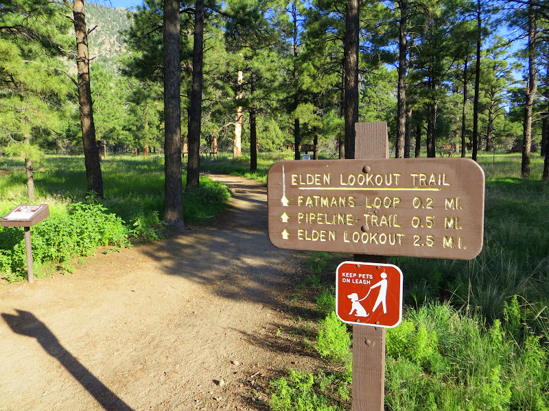
Mt. Elden trailhead

Although certainly challenging from a physical standpoint, once you reach the trail junction just below the lookout the hike becomes much less arduous, and with the exception of a 2 mile descent down a different rocky trail the remainder of the route is a pleasant and scenic ramble.


Sunset - Mt. Elden trail junction

Of course if you've still got some juice left in your legs upon reaching the junction, it's not too much of a detour to make the .2 miles to the lookout for some great views over the city and a closer look at the man-made forest of communications equipment installed on this lofty perch.


The Elden trail portion is located on the south facing side of the mountain, and as such receives full sunlight. This makes for a generally warmer and drier climate, and is reflected in the types of vegetation that populates the slope. When you make the transition to the north aspected Sunset Trail, the difference is dramatic and sudden.


In 1977 the human caused Radio Fire swept much of this area completely, denuding the slopes of trees. Despite the initial devastation the healing power of time has allowed for some recovery. At this elevation and latitude the first trees to reappear were the aspens, which along with other shrubby plants have begun the long process of rehabilitation.

The Sunset trail begins with a long, somewhat level traverse on the north side of Mt. Elden, eventually emerging onto a slender ridge connecting the main body of the mountain with the rest of the Dry Lake Hills. I really enjoy the Sunset trail for many different reasons, but particularly for the beautiful and vibrant color splashed across the mountain in fall.


Looking back on the Sunset trail towards Mt. Elden

Once on the airy, open ridge views to north include the tallest mountain in Arizona, the San Francisco Peaks.


The ridge served as a natural firebreak during the Radio blaze, and many of the trees at the top were spared. Here the path follows along the spine, dropping slightly in elevation as it nears the next waypoint.


After an easy mile of walking, the Sunset trail meets up with the junction of the Upper Oldham trail.


The intersection represents just one of the many loop possibilities found throughout the Dry Lake Hills trail system. For now we continue straight ahead, at first staying near the crest before dropping just below on the eastern face.


This scenic half mile segment offers the best view east over the outlying communities of Doney Park and Timberline, and beyond into the hazy brown and pink of the Painted Desert on the horizon. While enjoying the scenery, hikers should be aware that mountain bikes are permitted on the Sunset trail, and this downhill section has become fairly popular with riders.

As the Sunset trail makes a sudden turn to the west and downhill, the next section in this loop portfolio appears on the east side - the Heart Trail
.


Dropping quickly below the level of Sunset, the descent on the Heart Trail appears loose and rocky - which it is for at least the first few hundred yards. Soon however the path levels out enough to allow for looking up instead of carefully negotiating the steep, debris filled pitch.

One result of the 1977 fire was the removal of trees and shrubs which masked some of the more unusual rock pillars and outcroppings on this face of the mountain. Although the extent of revegetation is not as extensive in other places, enough has grown in to soften the contours of the jagged and harsh foundation that lies underneath.


Heart trail follows a descending ridge for the most part, making long graceful switchbacks through open air. Although the grade is moderate overall, a few places on this upper section feature enough of an incline with lots of rocks to warrant special attention.  Even so hikers have ample opportunity to take in expansive views as they make their way to the valley below.


The lower sections of Heart trail are characterized by frequent stands of Gambel or scrub oak, growing in family clusters.


The further down you go the more rocky the path becomes, requiring more attention to placement of the feet.


Much of the rubble is metamorphic in origin, but some of it springs from the few visible surface layers of sedimentary rock that once covered the entire region. Here is a rare outcropping of red sandstone seen along the way.


Nearing the base of the mountain the route becomes more brushy as it levels out, and isolated stands of ponderosa pine appear. Gradually the chunky red rock underfoot disappears to be replaced by sandy, white soil.


My only complaint about this otherwise excellent hike is that at the point where the Heart trail meets the Sandy Seep and Christmas Tree trails no signs exist to mark the junction. Anyone unfamiliar with the territory could easily take an errant turn and wind up heading the wrong direction. Just so you know - the correct answer is turn right onto the Christmas Tree trail.

The not-so-obvious and unmarked trail junction

At this point you should be heading generally west, contouring around the base of Mt. Elden. The path itself shows a fair amount of traffic and is easy to follow.


Soon the sounds of traffic along the always busy Route 66/U.S. Highway 89 fill the air, and despite the screen of trees it's hard to maintain the illusion of being deep in the forest far away from the trappings of civilization. I suppose this what it feels like to walk in Central Park in downtown Manhattan.

After about 1.5 miles, the Christmas Tree trail we've been traveling meets the easternmost extension of Fat Man's Loop, a circular route which is incorporated into the Elden Lookout trail.


From here it's only a short walk to the junction with Fat Man's Loop and the Mt. Elden Lookout trail, followed by the previously traveled .2 mile back to the trailhead and parking area.


By now you've covered over 8 miles (more if you took any detours like a trip to the lookout) and seen how varied and scenic the country is just on the other side of the hill, so to speak. You've gained and lost nearly a vertical mile in elevation, and probably lost a pound or two in sweat.

What you get in return is up to you, but from my perspective I can tell you the gift of a day in the natural world is one without price - especially if you are fortunate enough to see the sunrise over Mt. Elden like I have.

Sunrise from Mt. Elden