

Winter in this part of the country can bring challenges to the outdoor enthusiast, since most summer trails are covered in snow, roads to many trailheads are closed, and short days can limit the amount of time available for exploring. Of course if you are properly prepared there's no reason to sit at home and wish you were outside - I personally like an expression attributed to the Norwegians:
"There's no such thing as bad weather, just bad clothing".
One of my favorite winter destinations is the South Rim of Grand Canyon, which is located about an hours drive north of my home. The absolute best part of visiting during the colder months is that you can experience one of the world's greatest natural wonders without the summertime crowds.
South Kaibab Trail
For this particular outing I chose a well known and easily accessible trail called South Kaibab, which drops into Grand Canyon just east of the South Rim village. This steep but highly scenic route descends more than 5000 feet in elevation over 7 miles to reach the Colorado River at the bottom of the Canyon.
One thing any hiker planning a trip on Canyon trails in winter must have are traction devices, as snow on established paths quickly becomes packed into slick and slippery surfaces. Combined with steep grades and total exposure, the risk of falling into the depths of the gorge are very real and likely to end in fatality.
I personally use a product called Kahtoola Micro-Spikes, which are exceptionally easy to put on and take off, and they seem sturdy and well built. There are other devices out there which also offer some form of fall protection, but quality and design vary widely. Whatever you choose, make sure they'll stand up to rocky trails as well as ice.


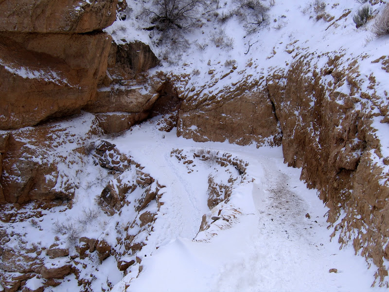
The first section of trail consists of relatively short switchbacks that drop several hundred feet along the exposed Kaibab limestone, which is the uppermost layer of Grand Canyon rock. This area receives almost no sun during the winter months, and you'll appreciate having something on your feet that keep you from sliding over the edge into the abyss.


While carefully picking your way down the trail, one should not forget to look up from time to time. The Canyon is always magnificent, and the perspective changes with each passing cloud and the continued loss of elevation.


A fairly long traverse follows the switchbacks, and although the grade is more moderate the trail continues to drop steadily. Depending on how cold it's been and how much snow has fallen, the trail can remain snow covered and icy for quite some distance into the canyon.
Although the sun angle is low for much of winter certain areas are situated where they see some light and warmth even in the deep cold of December and January. These areas tend to burn off and dry out more quickly than others. Conversely north facing slopes will hold ice and snow well into April.

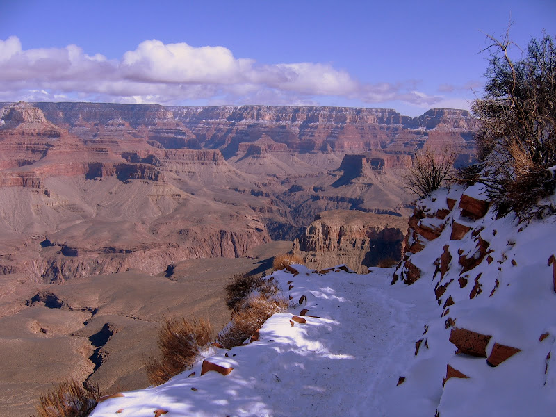
Snow in the Canyon adds a completely new dimension to already awe-inspiring scenery. The white "frosting" outlines the terraces and ledges of the Supai formation, adding depth and highlighting the multitude of layers.

The first benchmark of note is called Ooh-Aah Point, and is found at the .9 mile mark. The elevation here is 6320 feet, which means you've already dropped almost 1000 feet below the rim. Keep this in mind if you're feeling the effects of the hike on legs and lungs. Remember, what goes down must come back up!

The vista here is the first unobstructed view into the main Canyon since beginning the hike. Looking out and down the prominent landmark of O'Neill Butte dominates the foreground, with the Granite Gorge far below. By now the immensity of Grand Canyon becomes evident, with the scale of walls, mesas, buttes, and side canyons starting to make some sort of spatial sense.

Below Ooh-Aah Point the trail returns to a steeper descent, although here sun exposure had left much of this part of the trail free of snow and ice.

But don't take those traction devices off just yet - north facing aspects of the trail still sport plenty of snow.
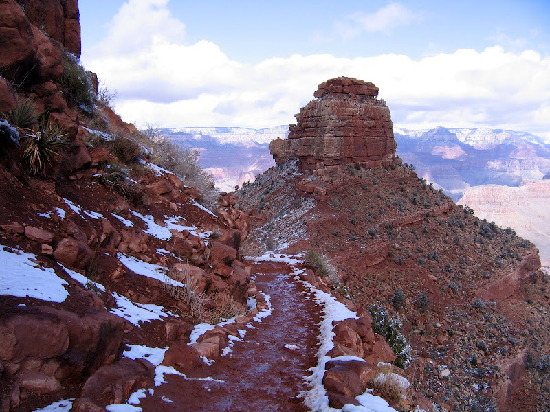
The trail follows a long spine connecting O'Neill Butte with the promontory ahead. Walking along the path ahead is straightforward and obvious.

Looking back, a flocking of white clings to exposed outcrops and ledges of the butte, forming a picturesque mosaic of rock and snow.


The South Kaibab is the shortest trail to the River. Along with Bright Angel trail, the South Kaibab is also the most heavily used path into and out of the Canyon. It has the distinction of being the last remaining Rim to River route that is used by mules to pack guests and supplies into Phantom Ranch. On this trip I see more mules than people, which is one reason why I love this hike in winter.

At 1.5 miles in and almost 1200 feet down, the popular day hike destination of Cedar Ridge appears. The Park Service has built composting toilets here to accommodate the large number of visitors, but that is the limit on amenities. The ridge itself offers some great scenic views up and down the main Canyon, and is a good turnaround point for first time or novice hikers.


Continuing on towards O'Neill Butte, melting snow quickly turns the trail bed into goo. I've done this hike a few times over the winter, and it seems like the worst of the mud begins in this general area, and lasts for about a mile further in. It's not a pleasant experience, but the absolute worst of it can be avoided by staying high on the sides of the trail bed or rock hopping the larger stones that line the path.

The snow line is dramatic as it stops at the edge of the mighty Redwall, the 700 - 900 foot high limestone barrier that occurs about midway into the depths. More than any other formation this sheer and almost unbroken layer of stone determines where and how trails make their way from Rim to River, usually along fault lines or areas where large slabs have slumped onto the lower bench.

The mud here is iron-rich, sticky red soil from the Supai formation, and it's what gives the Redwall it's distinctive color. It will also leave an indelible mark on boots and socks. I know, I've got several pairs of both that are forever stained earth red. That's o.k. - as far as I'm concerned it's better than any merit badge.

The lower you go the more the trail dries out, although shaded sections may still hold a semi-frozen mud/snow mix.

Looking ahead you can see where the trail zig-zags across the slope, using a break in the Redwall for the descent to the bench below.

Another long ridgeline points directly into the Canyon and leads to the top of the Redwall. The views to either side are the best east/west vistas of the entire trip.


This close up shows a view to the west and the Bright Angel trail as it descends below the Tonto platform and into the Inner Gorge. You can also see a spur trail of Bright Angel on the the platform which leads to Plateau Point, located 6 miles from the rim.

The plateau above the Redwall forms the foundation for this section of trail, which heads directly for the drop-off ahead.

The somewhat level walking of the last 1/2 mile ends abruptly at Skeleton Point. From here the descent of the Redwall begins in earnest on a long series of switchbacks. At this location you are 3 miles from the rim, and 2000 feet into the Canyon. The Park Service strongly recommends that day hikers turn around here, for most people will underestimate just how challenging the hike out will be. To go further or attempt to reach the Colorado River and return in one day is ill advised, although the strongest hikers can do it, particularly when the weather is cool.

If you walk a short distance past the point, you will get a good look at the long and steep passage leading through the Redwall cliffs. Imagine doing this hike on a summer day with temperatures well into triple digits, and you'll see why many people get themselves into trouble here.

I continue a bit farther, looking on to the first view of the Colorado River still nearly 3000 feet below.


A well constructed trail is an engineering marvel and also a work of architectural artistry. There are sections of the South Kaibab that can be admired as both, and the Redwall passage is one of these.
One interesting fact about the South Kaibab trail concerns its origins. It was constructed by the Park Service in 1924 primarily as a means for bypassing the Bright Angel trail which was at that time owned by Ralph Cameron.
Mr. Cameron charged each and every user a toll, and he fought many legal battles over the years to keep his business intact. Sadly for him, once the Hermit and Kaibab trails were in place, visitors no longer had to pay to reach the Inner Canyon, and he relinquished his rights to the Park.


This picture shows old worn out rock drills used as anchors for trail cribbing. When all your building materials have to be transported on mules or by foot, you make the most of what is on hand.

After 3.5 miles I reach the turnaround point for my journey. Located about halfway down the Redwall switchbacks, this is halfway between the Rim and River. Nearby is a nice rock outcropping to sit on and enjoy the lofty and encompassing views to the west.


After a brief rest and a bit of lunch, it's time to shoulder the pack and begin the 2500 foot climb back to the rim. Although much of the way I'll have my head down as I concentrate on putting one foot in front of the other, I can always take time to look up and reward myself with the magnificent views that surround me.
No matter how challenging the conditions or how steep the grade, making a pilgrimage to the world's greatest natural wonder never fails to satisfy me. It's even better as I near the top and begin to hum the tune to "Walking in a Winter Wonderland". The song may have been written with a Currier and Ives winter tableau in mind, but I think it's appropriate here too.

I am from france, I found your blog , your photos are wonderful; I send your blog to my friends in france.
ReplyDeleteThanks for this blog, my husband and I are mountain biker, hikers, etc. In love with Colorado but live and work in Missouri so your blog and brilliant pictures makes it bearable when we can't be there.
ReplyDeleteThank you for This blog, I am heading to the Grand Canyon Dec 27 for 3 days. I am glad that I saw your photos; and read your post.
ReplyDeleteThank you for taking the time to publish this information very useful! footcare drills
ReplyDelete