Saturday, May 5, 2012

On Foot Part XI - The Barnhardt Trail

With a blog focused on all things Colorado Plateau, I often overlook some incredible landscapes just outside the physiographic boundaries that define the region. In an effort to mitigate some of my neglect I recently made pilgrimage into a remote and beautiful area just south of Flagstaff, the Mazatzals.

Depending on how particular you are about pronunciation, you can say MA-ZAT-ZAL, or try to emulate the locals and say MAT-A-ZAL. Either way this rugged range lies in the Transition zone of Arizona, south of the Colorado Plateau and north of the Basin and Range province, and is characterized by steep and rocky mountains that rise to over 7000 feet from desert grassland foothills. With an area encompassing over 250,000 acres that has been designated as wilderness, access is limited to an extensive network of hiking trails that range from excellent to poor in condition.

Since this was to be my introduction to the area I selected the most popular access point, the Barnhardt Trail (#43). Despite the trail's reputation as a main artery into the wilderness, on this particular day I was the only one there, and I had the place all to myself.

At an elevation just over 4000 feet above sea level, the trail begins on a rocky alluvial bench that flows out of the canyon. Vegetation here is classic high desert, with pinon, juniper, agave, prickly pear, turbinella oak, a variety of cacti, and other drought adapted plants.


This member of the yucca family is sometimes called a "century" plant, arising from the mistaken idea that the plant blooms at the end of a hundred year lifespan. While it is true that the singular event of flowering signals the end of the plant's life, it actually occurs after a period of around 30 years.


The parking area for the trailhead is the takeoff point for several other wilderness trails, so care must be exercised when starting off. In a somewhat embarrassing admission I must relate that when I came through here earlier in the spring with the intention of hiking the Barnhardt, I instead took an unplanned journey for several miles among the foothills before I realized I was on the wrong path. When I returned to my vehicle a few hours later I immediately found the correct trailhead cleverly hidden in the trees just a few steps away from where I began my misguided trek. Oops.

The real trailhead begins with a warning about fallen logs and rolling rocks as a result of the 2004 Willow Fire, which currently ranks fifth in terms of Arizona's largest wildfires. This lightning sparked blaze consumed over 120,000 acres in the range, and left large parts of the landscape nearly barren and lifeless - at least for a while. On the hike I saw plenty of evidence of the resiliency of nature, both in terms of plants and animals.


The first section of trail is characterized by rocks, lots and lots of rocks. Not big rocks you can hop on and over, and not small loose rocks, but rocks like you would find in the bed of a large dry stream.


Fortunately as the trail begins a steady climb away from the ravine, the rocks become less of an issue. At first the grade is slight for a trail which will ascend over 1600 feet in approximately 6 miles, and the lack of tall trees leaves the hiker fairly exposed. I was grateful for the light down canyon breeze which provided just the right amount of cooling on a warm, cloudless mid-spring morning.


After nearly 20 minutes of walking, a sign appeared announcing the official boundary of the wilderness. The arbitrary nature of such demarcations struck me as amusing, since I felt like I'd been in an extremely isolated and "wild" environment from the moment I left the parking area.


The trail follows a ravine, traversing the southern flank of a canyon which dissects the mountain. Stony outcrops of Precambrian granite and schist loom overhead, heralding the rugged and daunting character of the landscape.


The aesthetic and visual appeal of the canyon increases exponentially as you make your way, while another sensual delight unfolds as you hear the sound of a stream hundreds of feet below. Although initially hard to spot, occasional glimpses of inviting pools and ribbons of glistening water appear from above.


I've often about expounded on the importance of water in other posts, as my appreciation for this vital resource was formed by coming of age in the desert. As someone accustomed to the absolute scarcity of what many others might take for granted, the sight and sound of flowing water fills me with gratitude and reverence for what truly represents life or death in this unforgiving environment.

With the presence of water abundant bird song echoed from cliffs and walls. I was pleased to hear a wide variety of calls including one of my absolute favorites, the laughing notes of the canyon wren.

Continuing on, the well established tread of the trail allowed time and miles to flow nearly effortlessly - that is when I wasn't stopping to admire the scenery or the local flora.


Massive rock faces ahead and across the canyon paint vivid pictures of incredible forces that shaped the once subterranean stone. As I contemplate the contorted layers, I recall an author who imbued the bones of the earth with consciousness, albeit a very ponderous and slow awareness.

In his portrayal of this sentience a single thought takes hundreds of thousands of years to form, and given the almost incomprehensible span of geologic time I can see the logic behind this idea. I imagine the stone feeling unrelenting anguish over the tortured bending and folding created by incredible heat and pressure, only now able to take some relief in the balm of fresh air and warm sunshine.


Taking a moment to gaze back across the Tonto Basin it becomes apparent that the trail is gaining altitude. Looking ahead reveals the long steady incline that awaits.


After an extended traverse, the terrain dictates a more aggressive grade in order to surmount a series of steep rock faces. The result is a series of switchbacks that ascend a ridge protruding into the canyon.


Clinging to a west facing wall I noticed this attractive tableau - a cactus garden thriving on a terrace of lichen encrusted rock. The appearance was very appealing to my eye, with muted colors and miniature Zen-like symmetry.


The switchbacks end with a long traverse into a side canyon featuring sheer reddish walls. The evidence of underground water is unmistakeable with the presence of lush vegetation and a profusion of moss growing from the rock face.



Emerging from the cool moist shadow of the ravine the trail once again swings out to the north, revealing a higher vantage point to look back over the canyon and the basin shimmering in the heat beyond.


Away from the canyon walls the trail is once again exposed and grows rockier. I spy a flock of turkey vultures soaring on thermals above me, just waiting for something to die so they can keep on living. I sincerely hope it won't be my turn feed the scavengers.


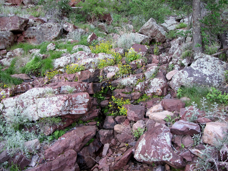
The path eventually winds back into another ravine, which at first glance appears dry. But as I cross the rocky stream bed, I hear the unmistakeable sound of running water beneath my feet, and glancing up and down the creek reveals a lush ribbon of green life, including this yellow flowering shrub I don't recognize.


Up ahead I encounter a section where a trailside garden of wild Arizona rose is working to take over the path, and for a brief moment the delicate and aromatic scent of roses perfumes the air.


Progress so far is leading to what appears to be the head of a tributary canyon branching off to the south. As the trail rounds the corner another surprise awaits ahead.


The previous side canyons have teased me with the allure of water, but aside from vibrant plant communities and water I can hear but not see, the cool, wet, life giving stuff has proved elusive. Not with this canyon. A series of small pools fed by a waterfall cascading from a pouroff finally fulfills the promise.


After pausing for a bit beside the oasis I continue onwards. I'm near the top on this side of the canyon, and the trail levels out for an extended haul.


I enter an area on the westward facing slope of a wide valley that was once covered in juniper and pinon pine. The Willow fire essentially wiped out the living trees, leaving naked white ghosts of bare branches and trunks. Earlier I mentioned how nature was working to restore the land, and here the void is being filled with an explosion of manzanita.


Looking across the valley, I can see it's at least another mile to the junction with the Mazatzal Divide Trail, which was to be my goal on this trip. But as I reach behind me to grab a water bottle from my daypack, I discover that it's no longer there. I recall a pretty significant stumble about 30 minutes earlier, and realize it probably fell out there (it did).

I'm also experiencing nagging pain in my left leg from a relatively minor injury the prior week, and the idea of crossing an ocean of manzanita isn't so appealing. I have another liter of water, but I decide not to press my luck and make this my turn around point for the day. Besides, I've seen enough to know there will be future visits including a longer stay, probably as a multi-day backpack once I figure out the logistics of water.


Despite the inconsequential setback, overall I am delighted with my experience. Like so many journeys I've made into places I've never seen before I discover more territory that invites exploration, and yet another place that holds the promise of outstanding outdoor recreation.

In the future I won't be so quick to look north to satisfy my everlasting need for beauty and solitude, especially now that I know what awaits here in the wild and remote wilderness of the Mazatzal mountains.


Wednesday, February 15, 2012

On Foot Part X - Grand Canyon In Winter


Winter in this part of the country can bring challenges to the outdoor enthusiast, since most summer trails are covered in snow, roads to many trailheads are closed, and short days can limit the amount of time available for exploring. Of course if you are properly prepared there's no reason to sit at home and wish you were outside - I personally like an expression attributed to the Norwegians:

"There's no such thing as bad weather, just bad clothing".

One of my favorite winter destinations is the South Rim of Grand Canyon, which is located about an hours drive north of my home. The absolute best part of visiting during the colder months is that you can experience one of the world's greatest natural wonders without the summertime crowds.

South Kaibab Trail

For this particular outing I chose a well known and easily accessible trail called South Kaibab, which drops into Grand Canyon just east of the South Rim village. This steep but highly scenic route descends more than 5000 feet in elevation over 7 miles to reach the Colorado River at the bottom of the Canyon.

One thing any hiker planning a trip on Canyon trails in winter must have are traction devices, as snow on established paths quickly becomes packed into slick and slippery surfaces. Combined with steep grades and total exposure, the risk of falling into the depths of the gorge are very real and likely to end in fatality.

I personally use a product called Kahtoola Micro-Spikes, which are exceptionally easy to put on and take off, and they seem sturdy and well built. There are other devices out there which also offer some form of fall protection, but quality and design vary widely. Whatever you choose, make sure they'll stand up to rocky trails as well as ice.


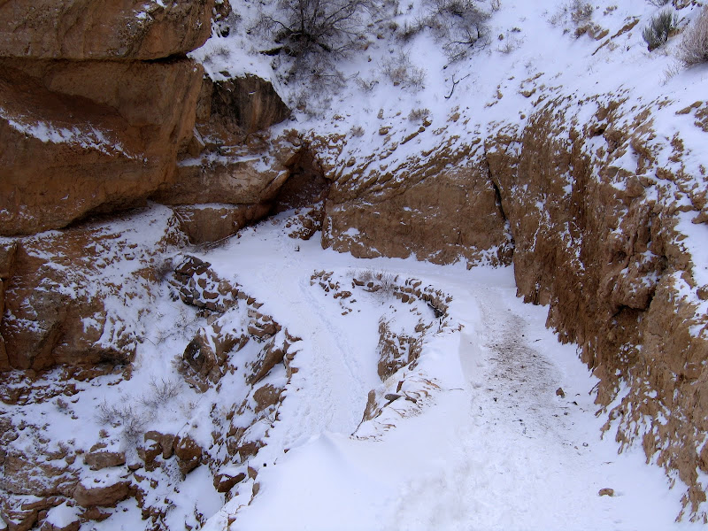
The first section of trail consists of relatively short switchbacks that drop several hundred feet along the exposed Kaibab limestone, which is the uppermost layer of Grand Canyon rock. This area receives almost no sun during the winter months, and you'll appreciate having something on your feet that keep you from sliding over the edge into the abyss.


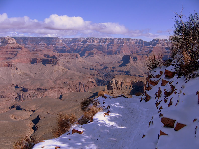
While carefully picking your way down the trail, one should not forget to look up from time to time. The Canyon is always magnificent, and the perspective changes with each passing cloud and the continued loss of elevation.


A fairly long traverse follows the switchbacks, and although the grade is more moderate the trail continues to drop steadily. Depending on how cold it's been and how much snow has fallen, the trail can remain snow covered and icy for quite some distance into the canyon.

Although the sun angle is low for much of winter certain areas are situated where they see some light and warmth even in the deep cold of December and January. These areas tend to burn off and dry out more quickly than others. Conversely north facing slopes will hold ice and snow well into April.


Snow in the Canyon adds a completely new dimension to already awe-inspiring scenery. The white "frosting" outlines the terraces and ledges of the Supai formation, adding depth and highlighting the multitude of layers.


The first benchmark of note is called Ooh-Aah Point, and is found at the .9 mile mark. The elevation here is 6320 feet, which means you've already dropped almost 1000 feet below the rim. Keep this in mind if you're feeling the effects of the hike on legs and lungs. Remember, what goes down must come back up!


The vista here is the first unobstructed view into the main Canyon since beginning the hike. Looking out and down the prominent landmark of O'Neill Butte dominates the foreground, with the Granite Gorge far below. By now the immensity of Grand Canyon becomes evident, with the scale of walls, mesas, buttes, and side canyons starting to make some sort of spatial sense.


Below Ooh-Aah Point the trail returns to a steeper descent, although here sun exposure had left much of this part of the trail free of snow and ice.


But don't take those traction devices off just yet - north facing aspects of the trail still sport plenty of snow.


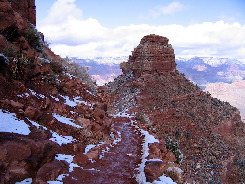
The trail follows a long spine connecting O'Neill Butte with the promontory ahead. Walking along the path ahead is straightforward and obvious.


Looking back, a flocking of white clings to exposed outcrops and ledges of the butte, forming a picturesque mosaic of rock and snow.


The South Kaibab is the shortest trail to the River. Along with Bright Angel trail, the South Kaibab is also the most heavily used path into and out of the Canyon. It has the distinction of being the last remaining Rim to River route that is used by mules to pack guests and supplies into Phantom Ranch. On this trip I see more mules than people, which is one reason why I love this hike in winter.


At 1.5 miles in and almost 1200 feet down, the popular day hike destination of Cedar Ridge appears. The Park Service has built composting toilets here to accommodate the large number of visitors, but that is the limit on amenities. The ridge itself offers some great scenic views up and down the main Canyon, and is a good turnaround point for first time or novice hikers.


Continuing on towards O'Neill Butte, melting snow quickly turns the trail bed into goo. I've done this hike a few times over the winter, and it seems like the worst of the mud begins in this general area, and lasts for about a mile further in. It's not a pleasant experience, but the absolute worst of it can be avoided by staying high on the sides of the trail bed or rock hopping the larger stones that line the path.


The snow line is dramatic as it stops at the edge of the mighty Redwall, the 700 - 900 foot high limestone barrier that occurs about midway into the depths. More than any other formation this sheer and almost unbroken layer of stone determines where and how trails make their way from Rim to River, usually along fault lines or areas where large slabs have slumped onto the lower bench.


The mud here is iron-rich, sticky red soil from the Supai formation, and it's what gives the Redwall it's distinctive color. It will also leave an indelible mark on boots and socks. I know, I've got several pairs of both that are forever stained earth red. That's o.k. - as far as I'm concerned it's better than any merit badge.


The lower you go the more the trail dries out, although shaded sections may still hold a semi-frozen mud/snow mix.


Looking ahead you can see where the trail zig-zags across the slope, using a break in the Redwall for the descent to the bench below.


Another long ridgeline points directly into the Canyon and leads to the top of the Redwall. The views to either side are the best east/west vistas of the entire trip.


This close up shows a view to the west and the Bright Angel trail as it descends below the Tonto platform and into the Inner Gorge. You can also see a spur trail of Bright Angel on the the platform which leads to Plateau Point, located 6 miles from the rim.


The plateau above the Redwall forms the foundation for this section of trail, which heads directly for the drop-off ahead.


The somewhat level walking of the last 1/2 mile ends abruptly at Skeleton Point. From here the descent of the Redwall begins in earnest on a long series of switchbacks. At this location you are 3 miles from the rim, and 2000 feet into the Canyon. The Park Service strongly recommends that day hikers turn around here, for most people will underestimate just how challenging the hike out will be. To go further or attempt to reach the Colorado River and return in one day is ill advised, although the strongest hikers can do it, particularly when the weather is cool.


If you walk a short distance past the point, you will get a good look at the long and steep passage leading through the Redwall cliffs. Imagine doing this hike on a summer day with temperatures well into triple digits, and you'll see why many people get themselves into trouble here.


I continue a bit farther, looking on to the first view of the Colorado River still nearly 3000 feet below.


A well constructed trail is an engineering marvel and also a work of architectural artistry. There are sections of the South Kaibab that can be admired as both, and the Redwall passage is one of these.

One interesting fact about the South Kaibab trail concerns its origins. It was constructed by the Park Service in 1924 primarily as a means for bypassing the Bright Angel trail which was at that time owned by Ralph Cameron.

Mr. Cameron charged each and every user a toll, and he fought many legal battles over the years to keep his business intact. Sadly for him, once the Hermit and Kaibab trails were in place, visitors no longer had to pay to reach the Inner Canyon, and he relinquished his rights to the Park.


This picture shows old worn out rock drills used as anchors for trail cribbing. When all your building materials have to be transported on mules or by foot, you make the most of what is on hand.


After 3.5 miles I reach the turnaround point for my journey. Located about halfway down the Redwall switchbacks, this is halfway between the Rim and River. Nearby is a nice rock outcropping to sit on and enjoy the lofty and encompassing views to the west.


After a brief rest and a bit of lunch, it's time to shoulder the pack and begin the 2500 foot climb back to the rim. Although much of the way I'll have my head down as I concentrate on putting one foot in front of the other, I can always take time to look up and reward myself with the magnificent views that surround me.

No matter how challenging the conditions or how steep the grade, making a pilgrimage to the world's greatest natural wonder never fails to satisfy me. It's even better as I near the top and begin to hum the tune to "Walking in a Winter Wonderland". The song may have been written with a Currier and Ives winter tableau in mind, but I think it's appropriate here too.