
 |
| William Wallace Bass - NAU Library Collection |
His years long association with the region resulted in many natural features being named for him, including the subject of this post, the North Bass trail.
The North Bass trail was constructed in the 1890s primarily to access various mining claims north of the river, but it was also used by Bass to conduct tours to Point Sublime. When it was completed, together with the South Bass trail it became part of the first developed rim to rim trail at Grand Canyon.
In the beginning a crude wooden ferry was used to cross the river, but eventually William Bass built a tramway to transport visitors. He also built a tent camp at Shinumo Creek, where he tended a garden and orchard to provide food for friends and family.
The completion of the railroad from Williams to the present day South Rim Village in 1901 and the subsequent construction of the El Tovar hotel in 1905 was the beginning of the end for the Bass empire. Ease of access by train and more modern lodging options diverted most tourists away from the rustic charms of Bass Camp, and after William retired from his business interests at the Canyon in 1923 the North Bass trail swiftly fell into disrepair.
Over the ensuing years the North Bass gained a reputation as one of the most challenging trails as rockfalls, erosion, and fire took their toll on the landscape. Fortunately in 2005 the National Park Service trail crews undertook the challenging task of reestablishing and repairing this historic route. Although still remote and relatively difficult, today the North Bass is a rewarding and scenic hike for experienced Canyon visitors.
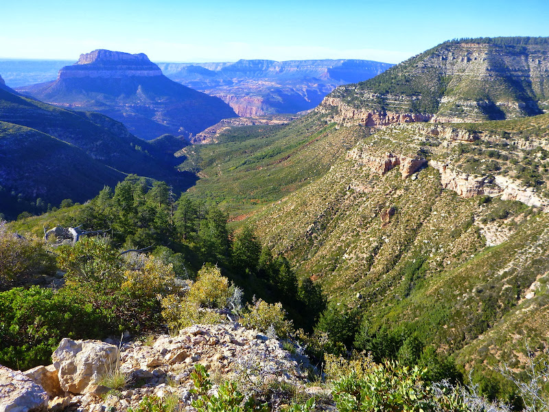
Swamp Point
Just getting to the trail head provides challenges to those who wish to enjoy it. Like most North Rim trails, the North Bass is located far from developed areas of the National Park. The start and end on the North Rim of the Kaibab Plateau means it is likely to be snowbound much of the winter, as back roads are not plowed. Additionally access may not be available by vehicle until later in the spring as Forest Service and Park Service crews must clear any down trees before roads will open to public.
If that weren't enough, summer and fall bring the possibility of fire or early season snow, and those who have a trip planned are wise to check forecasts and closures just prior to departure.
I won't detail the directions to the trail here, as the Park Service includes fairly concise instructions with the issuance of a permit. I do strongly suggest a current map of the North Kaibab Ranger District, as much of the off highway travel occurs through the forest before reaching a gate at the National Park boundary. Also be aware that at large camping is possible anywhere on the National Forest, but once you pass the gate you may not stay the night on the rim (or in the Canyon) unless your permit specifically allows it.
Once in the Park the last 8 miles of the journey to the trail head are suitable for high clearance passenger cars, although the road is narrow in places. The southern terminus brings you to a location on the rim prosaically named Swamp Point. There is usually ample parking available adjacent to the trail head, although especially popular seasons may force you to leave the vehicle at one of the turnouts along the way.
The North Bass Trail
The trail into the Canyon and eventually the Colorado River is 14 miles one way, although anyone who only wishes to make the trip as far as the bed of Shinumo Creek can shave 2 miles off that total. It primarily follows the drainages of White Creek in the upper section and then Shinumo Creek nearly all the way to the river. As trails go it is not especially difficult, at least on the scale by which Canyon treks are measured. Sure, it goes way down and then climbs way up, and the path is often rocky and narrow with some exposure, but hey it's the CANYON.......
North Rim trails have two aspects to them that makes them different from South Rim routes. First, due to higher elevation and the process known as headward erosion the trails are longer and farther away from the river. Second, because of a southern aspect they receive more sun and in some cases are more exposed. This makes them especially challenging as summer hiking destinations.
In the beginning the North Bass descends via switchbacks for a mile or so along a flank of Muav Saddle, which connects the sky island of Powell Plateau to the rim. Here the views extend mostly to the northwest and the prominence of Steamboat Mountain looming over the Esplanade. In this region the Canyon makes a wide turn to the north after a mostly east/west orientation, and the bulk of the Powell Plateau is the landform around which it curves.


At Muav Saddle a trail junction offers the hiker a couple of choices: Continue into the Canyon or climb up to Powell Plateau. A spur also branches off and leads a short distance to what is known as the Teddy Roosevelt Cabin.

The building was constructed in 1925 as a patrol cabin for the newly created Grand Canyon National Park. Although the 26th President of the U.S. never actually slept in it, it was built on the same spot where Roosevelt had camped in 1913 while hunting cougars in the area.
Somewhat ironically it was Teddy's love of bagging big game animals which ultimately led to his declaring much of the North Rim as the Grand Canyon Game Reserve in 1906, which was a precursor to what would eventually become a National Park in 1919.
 |
| View from Muav Saddle - Photo courtesy of Mike Wolf |


A fairly reliable spring or seep is found at the base of the Coconino, and at this point the trail begins a quick 1 mile descent to the bed of White Creek.
 | |
| North Bass trail descending into head of White's Creek |


After a couple of miles, the trail climbs out of the creekbed and begins to contour along the Supai layer just above the Redwall, crossing a series of 4 drainages. Just beyond the last drainage the path begins the steep drop through the imposing limestone barrier.


At the base of the Redwall the path resumes in the bed of the creek. Although water is usually present in White Creek, it is intermittent with stream flows occasionally disappearing from the surface.


Once again the trail follows the creek, this time confined to a narrow channel surrounded by towering walls of Redwall limestone.


 |
| White Creek below the Redwall - Photo courtesy of Mike Wolf |

 |
| White Creek below the Redwall- Photo courtesy of Mike Wolf |

There is a short bypass (1/2 mile) of a pouroff in the Bright Angel shale that briefly takes the trail out of the drainage and onto the Tonto before dropping back into the streambed. From here it continues a long and meandering negotiation of White Creek until finally climbing back out to the Tonto platform to the west.
 |
| The North Bass climbs onto the Tonto Platform - Photo courtesy of Mike Wolf |

The Tonto is an extensive bench formation found throughout Grand Canyon composed of eroded Bright Angel shale which rests on the Tapeats sandstone layer below. The relatively level and broad nature of the Tonto makes for excellent (but waterless and shadeless) hiking, and much of the east/west travel that is possible in the Canyon occurs here. The North Bass also makes good use of the Tonto to bypass a pouroff in White Creek and deliver the hiker to the final descent into Shinumo Creek.
 |
| The North Bass drops into Shinumo Creek - Photo courtesy of Mike Wolf |

 |
| Rocky switchbacks leading to Shinumo Creek - Photo courtesy of Mike Wolf |
 |
| Shinumo Creek - Photo courtesy of Mike Wolf |
Staying at the creek is just one option. Hikers can also continue 1.5 miles downstream to the Colorado, although it is likely you would end up sharing a beach with larger river parties. I recommend setting up camp at the creek and making a hike to the River, which not only assures more privacy but makes for a great layover day.
The setting at Shinumo Creek is also a worthwhile destination in and of itself, and just sitting back to absorb the grandeur would be a good choice for the visitor.


 | |||
| Stone hoodoos - harder "cap" rocks protects the softer rock below |
 |
| Artifacts at Shinumo Camp |


Even with the added effort, a hike along the creek to the River offers a chance to see beautiful scenes like this inviting plunge pool - a great place to cool off on a warm summer day.

Like many North Rim trails, you have to want to hike the North Bass. The best times for experiencing the North Bass are also the times when access may be impossible due to weather or road conditions. Also, because the window for the optimum hiking conditions are so narrow and the North Bass use area is one unit, you may have lots of competition for a backcountry permit.
But if chance is on your side and the weather holds, like some of the earliest visitors to the region you may be fortunate enough to experience one of the more remote and beautiful canyons found in the Park.
