Sunday, January 30, 2011

Grand Falls - Ephemeral Grandeur


What makes the western landscape so visually appealing are geological marvels shaped from the very bones of the Earth, apparently timeless monuments that appear unchanged over the lifespan of humans. It is rare that processes creating such splendor become the attraction, however Grand Falls is one such exception.

When people think of mighty torrents plunging into the depths, places like Niagra, Victoria Falls in Africa, or maybe Venezuela's Angel Falls come to mind. But longtime northern Arizona residents know another name - the Grand Falls of the Little Colorado River. This amazing natural wonder is not familiar outside the region primarily because it only occurs for a short while, and only after an especially snowy winter.

The Little Colorado is a tributary of the West's most famous waterway, the Colorado River. With headwaters forming in the higher elevations of the White Mountains of Arizona, the Little Colorado gathers snow melt in the spring, and transports it from east to west across the relatively flat Painted Desert. Where the river approaches the San Francisco volcanic field near Flagstaff, an ancient lava flow from Merriam Crater filled the river channel, forcing the water from the original bed.


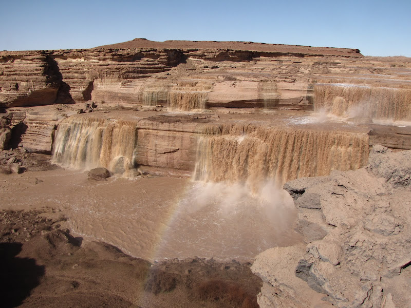
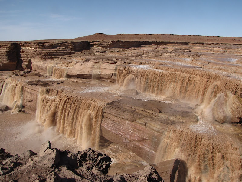
After the diversion the river eventually reentered the natural drainage, resulting in the falls. Over the last several thousand years water has continued to erode the underlying Kaibab limestone resulting in a stairstep cascade. Overall there is a drop of more than 185 feet to the base of the falls, making Grand Falls taller than Niagra.


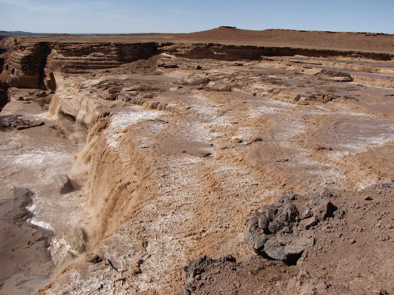
When the flows are near or at their peak, the spectacle is truly amazing. The river picks up enormous amounts of clay and silt from easily eroded badlands upstream, and this results in a muddy brown torrent. As sediment laden water plunges into the cataract, it is easy to see why earlier visitors dubbed the feature Chocolate Falls.


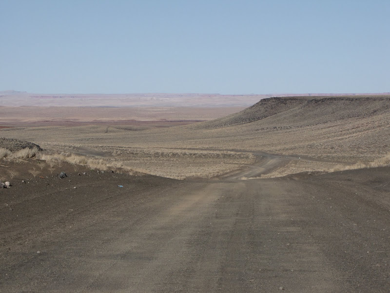
Finding the falls can be somewhat of an adventure, especially for the directionally challenged. The remote area is located on the Navajo Indian Reservation northeast of Flagstaff. While the initial approach uses paved roads, a significant portion occurs on primitive and poorly marked dirt "highways". I think the directions found on the Navajo Nation Parks site are the most accurate, although it suggests using four wheel drive. I have found a high clearance vehicle to be adequate, but the road is frequently very rough and washboarded.


The spectacle only lasts as long as the snow, and dry years often mean little or no water in the river. It is possible a heavy summer rain will generate enough flow for a decent display, but this lasts an even shorter period of time and it can be difficult or impossible to reach the site if roads are washed out or muddy.

If you find yourself visiting northern Arizona in the spring after a heavy winter, the falls are definitely worth checking out. To find out if there is enough water to make the journey worthwhile, check the stream flow data from the U.S. Geological Survey website here. In general flows above 1000 cfs mean the river is running high enough to justify a visit. If your timing is right you will witness a sight that is both awe inspiring and unexpected in the high desert.

Friday, January 28, 2011

Sinks Canyon - Wyoming!


My blog is devoted almost entirely to landscapes of the Colorado Plateau, as it is my favorite place which coincidentally happens to be located in my backyard. Occasionally I venture further afield than northern Arizona and Utah, and last summer I took advantage of extra free time and pushed farther north into Wyoming.

It was a trip into the past, as I once lived and worked in the Cowboy State. I came here first in the mid-1980's, drawn by vast open spaces and the fascinating frontier history of the area. I was fortunate enough to find a job in Cody for the summer, which was an amazing experience. That introduction led me to explore the entire state, and on that first journey I stumbled upon what I consider one of the most interesting and beautiful State Parks found anywhere in the west - Sinks Canyon


Over the years I returned to Wyoming several times to work and play, and Sinks Canyon became a favorite destination. It has changed very little in the last two decades, and I was happy to spend a few days reacquainting myself with the sights and sounds of this fascinating area. Located at the southern end of the rugged Wind River Mountains just north of Lander, Sinks Canyon was carved by the tumbling Popo Agie River. Popo Agie is pronounced “poe-poe-zhuh” with the “zhuh” sounding like the “sia” on the end of amnesia. The meaning translates as something like "gurgling river" and is from the Crow Indian language.


The forested canyon and boulder strewn torrent of the river are beautiful in their own right, however what makes the area even more interesting is the "mystery" of the river, specifically a phenomena called the Sinks, which gives the canyon its name.


The river, which boils and seethes in the channel upstream, disappears from the surface at the Sinks, going underground for nearly half a mile. It emerges in a much more subdued manner at the "Rise", a long pool filled with very fat and happy fish.


I say fat and happy because the fish are protected - no fishing is allowed at the Rise. In addition, State Park staff have provided a coin operated vending machine dispensing fish food, which visitors are all too happy to plug money into. The fish spend their day hovering beneath the viewing platform, waiting for the rain of nuggets from above. Fighting over food seems to be the extent of activity they get, but I'm sure they don't mind.

For those seeking an educational experience about the geology of the region including the Sinks, the Park has a small but excellent Visitor Center with exhibits and information regarding different facets of the canyon, including wildlife displays and historical artifacts from the earliest inhabitants.

One of my favorite aspects of the Park is a campground located on the banks of the river. Those who need all the bells and whistles for their RVs take note - there are no hookups, the sites are small, and only pit toilets exist for sanitation. Even so, there are more positives than negatives here. Most sites are within 25 feet of the water, and the white noise of the river provides a soothing backdrop for relaxing and sleeping.


Another great feature here is the Volksmarch Trail - volksmarch is a german word meaning "people walk". This nearly 10 mile long hike leads upstream to Popo Agie Falls, following the river high on the east bank through meadows and forest. Those who want a less strenuous outing can walk the much shorter Nature Trail, a one mile loop just across the river from the campground. Beautiful summer flowers abound along the way, inviting visitors to stop and admire the display.


In my book, Sinks Canyon is about as good as it gets, especially for a State Park right off the highway. The spectacular canyon setting includes interesting geology and a raging river at the doorstep of my camper, as well as great hiking and wildlife watching. It's a worthwhile destination, and I'm looking forward to another visit in the near future.