

Many times while touring some scenic backcountry route I'll come across other roads leading elsewhere, and I wonder what lies down that particular path. If the world were fair and just, I would have unlimited time to indulge those whims, but as it is I have to say "I'll come back and check it out". This of course means I'll never run out of places to go, as there are so many roads and trails to choose from and my time is not always my own.
This was certainly the case while driving the Burr Trail, an often overlooked detour through the southern end of Capitol Reef National Park and the far eastern extremity of the Grand Staircase - Escalante National Monument. Starting (or ending) on Utah Highway 12 in the hamlet of Boulder, this partially paved route connects at the other end with the Bullfrog - Notom road on the east side of the Waterpocket Fold, and continues north to Highway 24 or south to Hall's Crossing at Lake Powell. The road is passable to passenger cars to the boundary of the National Park, however the dirt portion of the trail is subject to flooding and washouts, so as always know the weather conditions before heading out.

In this particular instance the intriguing spur was the Wolverine Loop, a 28 mile unimproved road that offers access to some amazing canyon hiking experiences. I'll get to that a bit later. Anyone interested in venturing down this lonely road should have a high clearance vehicle and be prepared to deal with the kinds of emergencies that can happen in remote places. Also, like nearly all backcountry roads in canyon country, the Wolverine Loop is no place to be in wet weather.

Having driven past the turnoff to the south on numerous occasions, I finally felt the time was right to go exploring. Of course the irony of this decision is that along the way I encountered even more mysterious dirt roads leading to places as yet unknown to me - my "to do" list just keeps getting longer.....
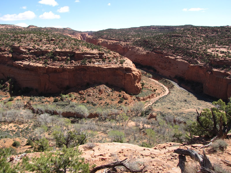
The Wolverine road is the entry point to several canyons which are part of the larger Escalante River watershed. Cutting through the Circle Cliffs are several watercourses that often take form as dry sandy washes. These seemingly insignificant and intermittent streams are carving their way through the orange-red Wingate sandstone as they drain the area of winter snowmelt and summer rains. Though frequently without surface water, the sudden and turbulent flash flooding from thunderstorms in July and August can affect a most noticeable change on the landscape in a single storm.
As a loop road it doesn't matter which leg you take or whether you travel in a clockwise or counterclockwise direction - both access points lead to the same places. If you are traveling west to east like me it is approximately 18.5 miles from Boulder along the Burr Trail to the intersection with the western leg of the loop road. No matter which way you go, there is a gradual descent ahead with far ranging views of the Circle Cliffs along with isolated mesas against the wide open sky.

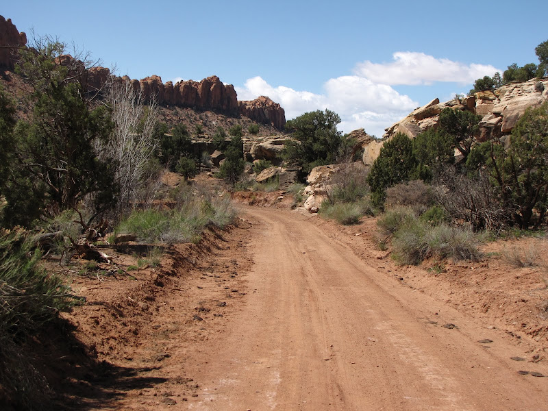
If your timing is right the county may have recently graded the road, as was the case when I visited. If not, be prepared for lots of washboards and slow drainage crossings. In one area in particular the road uses a normally dry streambed as the route for over a mile, meaning of course during thunderstorms there is a possibility of flooding.
On this western leg the first item of note is encountered at around 5.5 miles, where the mouth of Horse Canyon opens to the west. There is a sometimes open/passable 4x4 route down the wash that may be drivable in good weather. It is used by ranchers who run cattle throughout the area to monitor their herds. If you don't have a suitable vehicle or if the road is closed, it can also be hiked by itself or as part of a loop with one of the other tributary canyons found further along.
Speaking of other canyons, the next opportunity for exploration comes just a few miles down the road at the turnoff for the Wolverine Petrified Wood Natural Area.

Protecting the second largest assemblage of fossilized (petrified) wood found in North America, the Wolverine Natural Area is located near the mouth of Wolverine Canyon and offers a good look at some interesting specimens with a fairly short, easy hike. In addition there is even better hiking downstream to the confluence with Horse Canyon. I'll cover this unique attraction at some length in a forthcoming blog entry.

Continuing on, the road keeps heading in a south/southeasterly direction, contouring around finger-like ridges extending from the mesa. The base of red Wingate cliffs are mantled in reddish purple Chinle badlands formations, adding even more variety to the broad color palette of nature.

 The turnoff for Little Death Hollow appears soon after leaving the Wolverine Natural Area. Although the name is similar to a canyon found north and west of here, it is completely different in character and appearance. This trail leads down yet another steep walled chasm before eventually joining with Horse Canyon to complete the journey to the Escalante River. Like Wolverine and Horse Canyon this is an excellent outing for canyon hikers, especially since there are some great narrows near the far end. The story here is worthy of its own post, which I will publish at a future date.
At the culmination of the southernmost extension of the loop, the road begins a gradual turn to the east. Before swinging around on the return leg, another road appears leading further south.
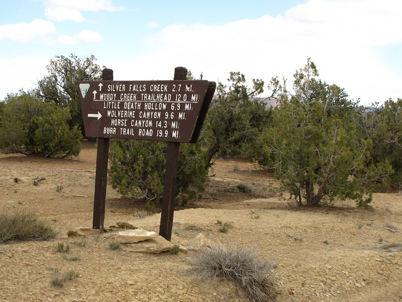
From here even more choices are offered for those with time and the willingness to explore. Silver Falls Creek and Moody Canyon beckon the desert wanderer with additional remote canyoneering experiences, something I'll have to come back for. (I know, it's on my list).
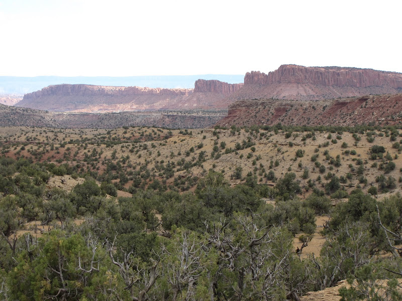
The remainder of the drive back to the Burr Trail offers plenty of scenery as the road gradually climbs, winding its way through ubiquitous Utah high desert country filled with pinon and juniper. There are no hiking trails located on this eastern leg, but the return journey offers the simple pleasure of solitary landscapes and rugged beauty.


A long time ago I used to say I never met a dirt road I didn't like. Since then I've become wiser and more experienced, and actually encountered more than a few roads I won't ever travel again. But the Wolverine Loop Road is not among those. In fact this is one of those places I'll have to come back to again and again, because like the petals of a flower the longer you look the more the mystery unfolds.

Appreciate that you took the time to write about your experience on this loop. I'm heading down the Burr Trail to explore (after a short drive down it last time I was in Escalante) and it was helpful to hear your perspective on it.
ReplyDeleteTHANK YOU! I am also heading down to backpack the loop and this write up was very informative
ReplyDelete