Sunday, May 31, 2009

North, Part 5 - Page and Lake Powell

Back at the junction of 89A and U.S. 89, we took a left towards the North Rim. But wait, we really wanted to visit Lake Powell instead. So let's backtrack and go the other way. U.S. 89A is the original highway, but in the 1960's access was needed to reach Page where the new Glen Canyon Dam was being constructed. Thus U.S. 89 was born. Today the highway is the major conduit from Flagstaff for travelers headed to the lake, the Grand Staircase - Escalante National Monument, Bryce, Zion, and into Utah in general.

The town of Page was built specifically to house the workers building the dam, but today it is the gateway to all the different recreation the region offers. Take a quick drive through town and see the neat and orderly way the area was laid out - odd considering it's a government town!

Glen Canyon Dam

Crossing over the Colorado River one last time, the road passes over the now drowned Glen Canyon at the damsite. Operated by the Bureau of Reclamation, the dam is an amazing example of man's efforts to wrest control over the environment from nature. I highly recommend a tour of the structure if time permits - departures are available several times a day from the Carl Hayden Visitor Center on the west side of the dam.

Lake Powell and Glen Canyon National Recreation Area

The enormous body of water impounded by Glen Canyon dam is called Lake Powell, and the entirety of the lake and much of the surrounding area are managed as Glen Canyon National Recreation Area. Offering over 1300 miles of shoreline, there are countless bays, coves and channels to explore. The more remote upper end of the lake offers solitude and backcountry experiences for those willing to leave the water. The lake is served by several marinas: Wahweap, the largest is located just 4 miles northwest of Page, and offers boat rentals, lake tours, lodging, camping, and just about anything else you'll need to enjoy your time here.

North, Part 4 Highway 89A - North Rim Gateway

North Rim of the Grand Canyon

Few visitors make the trek to see the North Rim of Grand Canyon, and that's a good thing. It is a longer drive, but you pass through some very scenic country. However the North Rim is only open from mid-May to mid-October, so make your plans accordingly. 42 miles north of the junction of 89 and 160. Highway 89A enters from the northwest. Turning left here. you begin contouring around the base of the Echo Cliffs, traveling towards one of only two vehicle crossings of the Grand Canyon in its nearly 300 mile traverse of the region.

As the highway makes it way to the head of House Rock Valley, you drop in elevation until you reach Navajo Bridge. The original structure was built in 1929, and it literally changed travel in the region in a way few of us living in the modern world of easy automobile access can understand. It finally linked communities in Arizona and Utah together, and it eliminated the often hazardous river crossing at Lee's Ferry. An almost identical new bridge was completed in the 1990s to accommodate the increased traffic in the region.

Lee's Ferry

Sent by the Church of Latter Day Saints (the Mormons) in 1871 to construct a crossing on the Colorado, John D. Lee chose a location near the confluence of the Paria and Colorado rivers. Today Lee's Ferry serves as the launching point for Grand Canyon river trips, and the 17 mile stretch of river upstream is considered a blue ribbon trout fishery. Part of Glen Canyon National Recreation Area, Lee's Ferry is managed by the Park Service.

After leaving the area of Navajo Bridge and Lee's Ferry, Highway 89a continues westward along the base of the majestic Vermilion Cliffs across House Rock Valley. The eastern edge of the Kaibab plateau looms in the distance, offering a climb up out of the often searing summertime heat of the valley. House Rock Valley has the distinction of being home to one of North America's few free roaming buffalo herds - but the chance of spotting one is very small. The area is vast, the buffalo few, and being intelligent creatures they too seek relief from the heat by ascending to the high country.

Vermilion Cliffs

28 miles west of Lee's Ferry and just before 89a begins its steady climb onto the Kaibab, a great backway intersects the highway at the base. Called House Rock Valley Road, it is part of the Vermilion Cliffs National Monument. It travels north along the edge of the plateau, and is the southern access point for the Paria Canyon area. The other end of the road emerges at U.S. 89 in Utah, and is a "shortcut" for the explorer. While in the area, keep your eyes on the sky - the endangered California condor is released near here after being raised in a captive breeding program - if you're really lucky you'll get to see one wheeling around in a thermal updraft with ease courtesy of its 9 foot wingspan.

Once we begin the ascent up the switchbacks of Highway89A, the barren landscape of the valley below gives way to trees - first the pinyon pine and juniper, then ponderosa. 14 miles after leaving House Rock Valley, you've reached Jacob Lake, where U.S. 89A meets State Route 67, the road to the North Rim. This forested plateau is an island of aspen and mixed conifer in the midst of the high desert around it, and it forms the northern edge of the great chasm. At an average elevation of 8000 feet and higher, it receives more snow in winter than the lower South Rim, which is why the North Rim side of the Park is closed for 6 months.

The actual Park entrance is still 31 miles south on Highway 67, but the drive is a pleasant one through dense forests and large open meadows.

North, Part 3 - Highway 89

On the northeast edge of town you'll find Highway 89, leading us north to the Grand Canyon - both the South and North Rims, Lake Powell, and the heart of the Navajo and Hopi reservations. On this side of the Peaks, the area is in a "rainshadow", so vegetation is not as lush, the local climate is bit drier, and we're on the edge of the San Francisco Peaks volcanic area, where the activity was the most historically recent.
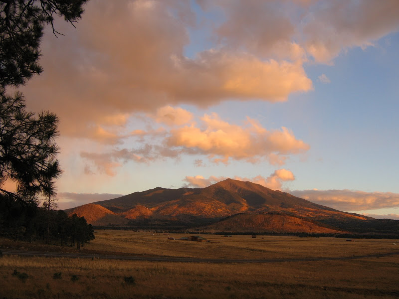
Sunset Crater


As mentioned before, the region surrounding the Peaks is part of a very large and formerly active volcanic field. Over 600 cinder cones and other related features created in the last 6 million years dot the landscape. 
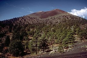
The most recent activity occurred just over 900 years ago at a place called Sunset Crater. Somewhere around 1080 to 1150 a.d. continuous eruptions formed the classic cinder cone. Native people living nearby were witness to the activity, and undoubtably their lives were changed as a result. The area and surrounding environment were shaped by eruptions and lava flows that still look as though they happened yesterday. Fortunately things have cooled off considerably, and the area has a number of hiking trails in and around the features. The area is now managed by the Park Service as Sunset Crater National Monument, and is located 12 miles northeast of Flagstaff on U.S. Highway 89.

Wupatki National Monument

After visiting Sunset Crater, visitors can continue on the scenic Sunset Crater - Wupatki
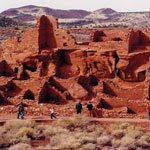
 Loop Road to Wupatki, where 800 year old pueblo ruins are scattered across the high desert. Remnants of the vanished Anasazi culture, the abandoned structures tell of life in the shadow of the mountain. The ruins are scattered over a fairly wide area, and some can only be visited when Rangers lead scheduled hikes into otherwise off limit areas. Both Wupatki and Sunset Crater are located in close proximity, and visiting both monuments are a great option for a day's worth of activities.

The Navajo Nation, Cameron, and Highway 64 to the South Rim of Grand Canyon

After leaving Wupatki, turn right on U.S. 89 to continue the journey north. Soon after rejoining the highway, you'll enter the Navajo Reservation, which is the largest in the U.S. Covering 26,000 square miles in 3 states, the land sprawls across much of the southeastern edge of the Colorado Plateau. Characterized by stark badlands, buttes, and mesas the area is home to over 298,000 tribe members, most who live in widely scattered and remote settlements.

51 miles north of Flagstaff you'll encounter the intersection of U.S. Highway 64 coming in from the west. This scenic road leads to the eastern entrance of Grand Canyon located at Desert View (map). This road roughly follows the rim of the Little Colorado canyon as it travels northwestward towards the confluence with Grand Canyon. During the busy summer months it can be a less crowded place to experience the Canyon.

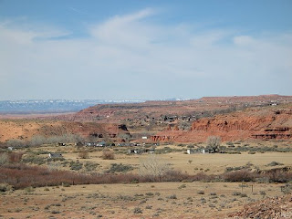
2 miles north of the highway intersection you'll enter the roadside community of Cameron. This is a good place to purchase authentic Native American crafts, as the store is owned by the Navajos, and the tribe will only sell the genuine article. The town itself is just south of the the Little Colorado gorge, and when passing over the bridge you'll often see the thin muddy trickle of water that exists most of the year.


Highway 160 to Monument Valley, the Four Corners and Navajo National Monument

14 miles to the north U.S. Highway 160 enters from the northeast. Travelers heading for Monument Valley, the Hopi mesas, Navajo National Monument, the Four Corners, or southwest Colorado should turn right here.

Tuba City and The Hopi Reservation

The oddly named Tuba City (a corruption of the Hopi name Tuuvi) and the companion community of Moenkopi mark the intersection of highway 160 with SR 264, a road that travels southeast to the Hopi Reservation. Visitors who wish to visit the Hopi communities on First, Second, or Third Mesas can travel the 50 miles or so to see what is believed to be the oldest continuously inhabited community in North America at Oraibi, founded around 1100 a.d.
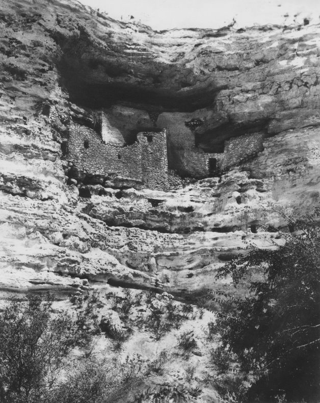
Navajo National Monument


The southwest is well known for the many prehistoric dwellings found throughout the region, but one of the best that few people know of is located on the Navajo reservation in northeastern Arizona. In remote Tsegi Canyon, ancestral puebloan peoples farmed the creek bottoms and lived in lofty cliff dwellings over 700 years ago. Keet Seel and Betatakin preserve the past history of these former residents. The ruins can only be accessed by guided Ranger tours, and are subject to seasonal availability. Navajo National Monument is reached by turning north onto S.R. 564, located 54 miles northeast of Tuba City.


U.S. 163 - Kayenta and Monument Valley

72 miles north of Tuba City is the town of Kayenta, where you'll find U.S. Highway 163 heading north for Monument Valley and Utah. The community is a good place to gas up, since towns are few and far between out here. Turning north onto U.S. 163, the highway climbs out of the valley where you'll spot a startling landmark thrusting skyward
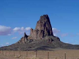
 - Agathla Peak. This jagged spire is the remnant of a volcanic plug after the softer sedimentary rock surrounding it eroded away. It sets the stage nicely for the better known sights ahead.


Monument Valley

Next to the Grand Canyon, probably the next most popular Four Corners destination is the iconic setting for so many Western movies - Monument Valley. The towering mesas, needles and buttes are massive sentinels over the lonely landscape. The area is located on the reservation, and is managed by the Navajo tribe, so be sure to stop in at the monument headquarters for available tours and information.

Four Corners

For those folks who want the distinction of being able to places parts of the body in four states at one time, you'll need to backtrack from Monument Valley to U.S. 160, and continue for 159 miles
to the Four Corners Monument. Just be warned that more accurate mapping recently conducted shows the actual state boundaries may not be where the monument is. Read this article for more information.

North, Part 2 - Arizona's Biggest Erosion Problem


O.K., we've left the pines behind temporarily on our journey to the "big ditch". As we drop out of the area surrounding the San Francisco Peaks volcanic field, the relatively flat terrain of the Pinyon-Juniper woodland emerges. Home to many wild animals, you're likely to spot mule deer, elk, pronghorn, coyote, or if you are fortunate, the shy and elusive javelina. At about 47 miles north of Flagstaff, you'll reach the junction of U.S. 180 and Highway 64 (coming from Williams). At the crossroads (this bump in the road is named Valle) are a couple of interesting sights: Turn left to visit the Planes Of Fame museum, where vintage aircraft are on display. For a visit to the days when "tacky" best described roadside attractions near National Parks, don't miss Bedrock City, home of the Flintstones.

A lot of people visiting the Grand Canyon for the first time are confused by the topography. Looking around from the intersection of Highway 180 and 64, they don't see anything resembling the Grand Canyon they've seen in pictures, even though the road signs tell them the Park is only 21 miles away. Ah, but wait - what most don't realize is that the Canyon is carved out of the surrounding high plateau, and your first glimpse won't come until you're nearly at the edge. Drive on!

The Grand Canyon

A rancher living in the area of the Canyon had never actually visited the natural wonder. One day he made the trip to see what all the fuss was about. Standing on the edge of the great chasm for the first time he was struck dumb with wonder. A companion asked him to say something about his thoughts on the subject. The old cowboy waited a minute, then finally said: "It's a helluva place to lose a cow".

There's not much I can add to the volumes written about what is arguably considered the world's greatest natural wonder. The Grand Canyon is so massive as to defy easy understanding or description. It stretches for 277 miles along the course of the Colorado River, and it yawns a mile deep and nearly 18 miles across at the widest. What I will say is this: Most visitors to this immense geological playground barely scratch the surface.

People travel from all over the world to see the Canyon, but the average length of time spent in the Park is less than 2 hours. It is understandable - the Canyon is not an easy place to experience, and it takes a real commitment of time and energy to explore beyond the sterile and safe boundaries of the established
facilities. Most folks visit the viewpoints, walk around the rim, take in a Ranger program or two, and then leave, feeling as though they've "seen" the Grand Canyon.

When you stand on the rim, at first you feel as though you are witnessing something beyond your comprehension, and you are right. The lack of recognizable and measurable landmarks denies the average visitor a sense of scale, and for many the Canyon vista quickly becomes two dimensional. It is not until you
descend below the rim that your mind can start to make sense of the grandeur that is before you. I realize not everyone is able or willing to hike on trails into the gorge, but if you can take the time, the rewards are well worth it. Even a short trip on the Bright Angel or Kaibab trails will give you a better perspective, but heed the warnings - the interior of Grand Canyon is not a place for the faint of heart.

Saturday, May 30, 2009

North, Part 1 - The Volcano

I don't want to take anything away from the wonderful places to visit I've already listed, it's just that the farther north you go, the deeper you venture into what I consider the best showcase of geography on the planet. Southern Utah used to bill itself as the "Greatest Earth On Show", and in many ways they win the award hands down. But let's not shortchange the comparable terrain you'll find just up the road from town. And yes, the Grand Canyon is on my list.

U.S. Highway 180

There are two roads leading north out of Flagstaff, and both lead to the Grand Canyon. This is where the similarities end. U.S. Highway 89 departs town from the northeast, and skirts the edge of the Painted Desert into the Navajo Indian Reservation. I'll cover that highway and its attractions in depth later on.

For the most scenic route to the Canyon, I recommend U.S. Highway 180. This route contours around the flanks of the San Francisco Peaks, eventually reaching just over 8000 feet in elevation. The road passes through towering stands of ponderosa and aspen forest before dropping into the pinyon-juniper environment found around 6000 feet. The only caution is that during winter U.S. 180 can be slick, icy, and possibly closed due to drifting snow, where Highway 89 typically is not.

Arizona Snowbowl Ski and Summer Resort

7 miles up the highway from town, you'll reach the turnoff to the Arizona Snowbowl. The Snowbowl is one of 4 ski areas that exist in Arizona, and is one of the nation's oldest, having begun operations in 1938. Located high on the slopes of the San Francisco Peaks, the area offers great winter and summer recreation opportunities. In winter skiers and snowboarders enjoy an average 260 inches of dry southwest powder on over 32 runs with an overall vertical rise of 2300 feet. In summer the area offers scenic chairlift rides on the main lift, where at the top you can view outstanding panoramas of much of northern Arizona from 11,500 feet. Just taking the drive up Snowbowl Road (7 miles each way) to the area is worthwhile, especially in fall as aspen trees turn rich yellow and orange colors against the somber green backdrop of fir, spruce, and pine.

Hiking the Peaks

For those hardy souls looking to "bag" Arizona's tallest mountain, the Humprey's Peak trail is the ticket. At 4.5 miles and over 3200 feet elevation change each way, you'll know what kind of shape you're in pretty quickly. The trail begins easily enough as it switchbacks through mixed conifers and aspens down low, but even so you'll feel the lack of oxygen. Just below the saddle, you'll be huffing and puffing as you switch into "mountain goat gear" to negotiate the loose volcanic soil above treeline. When you reach the summit, you'll be rewarded with outstanding views across much of the area, including the North Rim of the Grand Canyon. A cautionary note: During the summer thunderstorm season (typically July to early September), hikers are advised to get an early start, and be below treeline before the lightning starts.

If you want to experience the beauty of the Peaks with a lot less effort, then you should check out the Kachina Peaks trail. Where other trails make for the ridges or summit of the mountain, the Kachina trail traverses in a gently rolling fashion across the southern flanks of the Peaks, through small open meadows, lush aspen groves, and mixed conifer forests. Here the destination (5 miles each way) is not nearly as important as the journey, and makes for a great day outing.

Lava River Cave

The entire region surrounding Flagstaff was once the scene of frequent vulcanism, with the Peaks being the largest remnant of this history. Another very cool (literally) feature of this geologically hot period is the Lava River Cave, a mile long magma tube where intrepid hikers can experience utter darkness and the kind of complete quiet found only deep underground. A flashlight (an extra is always a good idea!), good walking shoes, and warm clothing are essential to enjoy this subterranean wonder. To get there, drive 9 miles north of Flagstaff on U.S. 180 and turn west (left)on F.R. 245 at milepost 230. Continue 3 miles to F.R. 171 and turn south 1 mile to where F.R. 171B turns left into the parking area.

Red Canyon Geological Area

25 miles north of Flagstaff on U.S. Highway 180, you'll find a very unusual and visually appealing landmark - Red Canyon Volcano. Red Canyon is a cutaway model of a cinder cone, where the side of the mountain has been sliced off, exposing the heart of the volcano. A short hike leads into the interior, and a visitor could be excused for thinking they had stumbled into a miniature version of Bryce Canyon. Rock pillars and fluted columns grace the wall of an amphitheater like setting. This feature makes a great short day hike on the way to Grand Canyon. Located 25 miles northwest of Flagstaff, at milepost 247 on U.S. Highway 180

Eastern Intrigue

The main route out of town to the east is Interstate 40, which skirts the southern end of the Navajo Reservation and ultimately leads to New Mexico. Along the way are great examples of prehistoric native cultures and interesting natural phenomena.

Walnut Canyon National Monument

Just a short 7.5 mile drive east of the city is the first of three National Monuments located within 20 mile radius of Flagstaff - Walnut Canyon National Monument. 700 years ago native peoples lived in cliff dwellings in this narrow canyon, where running water provided the foundation for life. Several trails explore the site, including a long steep staircase into the canyon. To get here, Take exit 204 off of I-40.

Meteor Crater

The idea of an object from space hurtling through the atmosphere to strike the planet is one we don't contemplate much, although a visit to this landmark brings the possibility to your attention. As one of the best preserved impact craters around, Meteor Crater has been studied and analyzed for what it tells us about our planet's past and likely future. The crater was also used by NASA during the Apollo space program to prepare astronauts for the physiography of the Moon. To see this natural feature, turn off the interstate at exit 233 about 35 miles east of Flagstaff.

Homolovi Ruins State Park Here lies a little known and seldom visited collection of archeological sites dating from the early ancestors of the Hopi people, commonly referred to as the Anasazi or ancestral puebloan people. Settlers here depended on the Little Colorado river for their survival, farming in the floodplain before eventually migrating northward to the mesas. Homolovi was one of the few safe places to ford the river, and as such became part of a significant trade route with other native peoples of the region. Located near Winslow about 58 miles east of Flagstaff. Take exit 257 north to Highway 87, then left on Honani Rd.


Petrified Forest National Park

Set in the badlands of the Painted Desert, the Park preserves a wealth of treasures including colorful petrified (fossilized) wood and ancient ruins. The setting is one of desolate beauty, and silence and solitude are easy to find in this stark landscape. Located about 120 miles east of Flagstaff, take exit 311 off I-40 to visit this remote and fascinating area.

South in the Fast Lane

When heading south from Flagstaff the major attractions can be reached via Highway 89A. This congested and narrow two lane highway negotiates steep canyon switchbacks, and the outstanding scenery along the way frequently results in slow moving traffic.

Visitors who wish to skip the often frustrating drive through Oak Creek Canyon can elect to bypass it entirely in favor of the freeway. Highway 89A parallels Interstate 17, and both roads eventually arrive at the same destination. Additionally there is one place worth seeing that can only be accessed off the interstate - Montezuma Castle.

Montezuma Castle and Well

Showcasing one of the best preserved cliff dwellings in North America, Montezuma Castle is neither a castle nor built by the famed Aztec leader. It is a fine example of how native people lived in this harsh environment using natural features of the landscape to their advantage. Built by the Sinagua, the area encompasses cliff houses and pueblo ruins as well as evidence of irrigation and farming techniques that predate those in use today.

Even though the inhabitants left the area over 600 years ago, you'll still get an appreciation of what life would have been like for those who called this area home.

4 miles down the road from the Castle, you'll find the turnoff (exit 293) for another very interesting and unique natural feature of the landscape, Montezuma Well. The well provides life giving water to a wide variety of flora and fauna, some found nowhere else on Earth. In the surrounding area you'll also see more examples of prehistoric Sinagua dwellings like those pictured here.

Friday, May 29, 2009

Going Down South

The story goes like this - an early promoter of statehood for Arizona was trying to convince Gen. William T. Sherman to return to Washington and lobby Congress for the state's admission to the Union. Pleading his case, the man said to the General: "Why, all Arizona really needs is a better class of people, more water, and cooler temperatures....."

"Son" replied Sherman, "that's all Hell needs too"


I admit I rarely travel south. There are two reasons for this. First, after leaving Flagstaff the terrain begins to lose elevation until eventually you reach the Sonoran desert. Intensely hot and dry in summer and full of venomous creatures and spiny plants, the desert is a place best visited in the winter.

Second, the low country is home to one of the fastest growing cities in the nation - Phoenix. This sprawling metropolitan blight on the land has everything a world class city aspires to - arts, culture, major sports franchises, shopping, and all the other features associated with large populations. Unfortunately it also encompasses world class traffic, crime, pollution, and suburban sprawl.

Of course Phoenix is not all there is to central and southern Arizona - far from it. It's just that for my tastes there are more appealing places just north of Flagstaff where scenery and solitude can be found with relative ease. That said, there are attractions to the south within an hour's drive that are worth checking out.

Sedona/Oak Creek Canyon

High on travelers lists of things to see in Arizona should be Sedona/Oak Creek Canyon. This astoundingly scenic area is located at the southern edge of the Colorado Plateau, where colorful red rock canyons, buttes, and spires are carved into the soaring cliffs.

From Flagstaff take the scenic route - Highway 89A south is a twisting and meandering road that descends steeply into beautiful Oak Creek Canyon. Anyone in a hurry should avoid this popular drive, as other visitors often slow traffic considerably while they "ooh and ahh" over the scenery.

As Oak Creek cuts down into the plateau it reveals colorful layers of sandstone and limestone that form towering cliffs rising on either side. It is one of Arizona's rare and precious riparian environments, with lush vegetation and perennial water - something you really learn to appreciate in the dry Southwest.

On the way down, be sure to stop at Oak Creek Vista at the top of the switchbacks for a great view of the canyon. Here Native American vendors sell handmade crafts to throngs of tour bus passengers who make this a key stop on their route.

At the lower end where the canyon begins to open up, you emerge into the world renowned red rocks of Sedona. In any other state Sedona would be a National Park, but in a land of superlatives it's just another pretty place.

A large community has grown up in the midst of this spectacular landscape, detracting only slightly from the aesthetic appeal. Even so the area abounds with sweeping vistas and hiking trails of every description - from easy day hikes on slickrock to steep scrambles up talus slopes. The Red Rocks -Secret Canyon Wilderness has the best trails, but plenty of other options exist as well.

Verde Valley

Venturing further south, the now four lane Highway 89A cuts through the growing heart of the Verde Valley. "Verde" is spanish for green, and the anglo explorers were referring to the broad belt of cottonwood trees and shrubs that line the banks of the river, which also bears the same name. A warmer and drier climate here attracts many retirees, and the relatively low cost of living makes the Verde Valley an affordable alternative for much of Sedona's workforce.

The town of Cottonwood is the next on the map, and has the largest population in the valley. Nearby is Clarkdale, home to the Verde River Canyon Railroad and Tuzigoot National Monument. The railroad offers a relaxing trip upriver through the ruggedly beautiful Verde river canyon, where wildlife and scenery compete for the passengers attention. Tuzigoot displays ancient dwellings dating back to the 12th century, formerly home to native Sinagua (spanish for "without water") peoples who once lived and farmed the fertile river bottom.

Jerome

Perched on Cleopatra Hill is the distinctly American mining town of Jerome. Much has been written about this "town on the move" (a sly reference to the fact that the slope where the town is situated caused buildings to migrate downhill) and the history of the area includes the boom and bust of rich ore producing mines, followed by the renaissance of the community due to an influx or artisans and craftspeople.

Nearby is the equally fascinating Gold King Mine, where you can view relics of the past arrayed around an old working mine. It would be easy to spend most of a day poking around the vast collection of machinery, vehicles, and buildings while enjoying the rustic atmosphere.

Perkinsville Road

Just before arriving in Jerome on Highway 89A, a road less traveled awaits the adventurous. Known as the Perkinsville Road (F.S. 318/County Rd. 73), this well maintained dirt backway travels 63 miles up and over the sides of Woodchute Mountain before dropping back down into the Verde Valley. Along the way you'll get great panoramas of the surrounding area, including the red rocks above Sedona.

The other end is known as the Overland Road, which traces a path used for centuries by ancient humans and cattle ranchers. It emerges high in the ponderosa pine forest near Williams, and makes a great loop for travelers heading back to Flagstaff after a day or more of exploration.

Go West, Young Man!

"With the completion of the Interstate Freeway System, it became possible to travel all the way across the country, from coast-to-coast, and never see a thing...." Charles Kuralt


Westwards from Flagstaff along Interstate 40 lie the cities of Williams, Ash Fork, and Seligman. Each has their own claim to fame, and I won't bore you with details (unless you really want to know why Ash Fork calls itself the "Flagstone Capital of the World"). What makes them interesting is their shared history as way points along the almost vanished Route 66, the original Mother Road. Though the towns were largely bypassed by the construction of Interstate 40, the local Main Streets preserve much of the flavor and appearance of this legendary road. Ash Fork is the gateway to one of the longer remaining stretches of 66, which continues to Kingman some 112 miles distant. I especially recommend Seligman, where quirky local businesses have emerged to capture the attention of the few folks who wander off the beaten path.

If getting your kicks on Route 66 is part of your travel plans, you might want to think outside the box. I'm referring to one of the most unusual side trips in the region - a drive to the bottom of the Grand Canyon. That's right, I said drive.

About an hour's drive west of Seligman on old Route 66 you'll reach Peach Springs, location of Tribal headquarters for the Hualapai Nation (the same people who built the much publicized Grand Canyon Skywalk). Here you'll find the only drivable access into Grand Canyon. Most folks call the road Diamond Creek for the stream that enters at the very end of the trail, others call it Peach Springs Road for the canyon it travels. Either way, it's a scenic 20 mile dirt road that descends through layers of geologic time to reach the Colorado River at the bottom (see image above). For most of the way the surface is graded dirt, but the last few miles require a high clearance vehicle.

Since the road is located on Tribal land, users need to pay a per person fee to access it. The road can wash out completely in the summer months due to afternoon thunderstorms, but the tribe uses it as a take out for Grand Canyon river trips, so they do their best to keep it open. Stop in at the relatively new and modern Hualapai Lodge in the center of town to inquire as to road conditions and pay the necessary fees.

Grand Canyon Caverns

To continue exploring off the beaten path, why not visit another relic of the glory days of old Route 66 - Grand Canyon Caverns. Once a thriving tourist stop for cross country travelers, the Caverns fell on hard times with the completion of the interstate. Today it is making a comeback thanks to nostalgia for the "good old days", and you can experience for yourself what it's like to travel over 250 below ground in a rare "dry" cave. As an added bonus, the restaurant serves pretty decent home style cooking. The caverns are located approximately 25 miles west of Seligman on old Route 66.

My Backyard

The Four Corners area includes a lot of real estate. To begin exploring the region a good place to start is my hometown. Flagstaff, Arizona is a gateway into the heart of the region, and there is much to see and do right here.


For the uninitiated, much of Arizona is rightfully considered a desert where abundant sunshine and warm temperatures are the norm. Many snowbirds flock to the southern half of the state during the winter months to escape the gray and frigid extremes of their hometowns. The cities of Phoenix and Tucson share a well deserved reputation for hellishly hot summers, where air conditioning is not merely a luxury but a necessity.

What many who have never visited don't realize is that Arizona is actually a land of much geographical diversity, with elevations ranging from 100 feet above sea level near Yuma to over 12,600 feet on the San Francisco Peaks (pictured above). This wide spectrum of environments over a relatively short distance means it's possible to spend a February morning skiing in Flagstaff, and then hop in the car for an afternoon tee time on the golf course in Phoenix.

Flagstaff is a good example of what most people don't know about Arizona. Situated on the southern edge of the Colorado Plateau at around 7000 feet and surrounded by a vast forest of Ponderosa pine, temperatures here rarely exceed 90 degrees and average around the high 70's/low 80's for much of the summer. In winter the coldest month is January with a mean daytime high of 43 degrees, and lows in the teens. What makes the climate especially enjoyable is the relatively low humidity, generally around 10%.

The region receives most of its' precipitation in the form of snow. In fact, Flagstaff averages 100 inches per year, making it one of the top 10 snowiest cities in the U.S.

In summer, daily afternoon thunderstorms referred to as the "monsoon" can dump heavy rain in localized areas, often accompanied by gusty winds and frequent lightning. Because of the relatively high elevation, Flagstaff and the surrounding area experiences a true four season climate that allows for a wide range of outdoor activities year-round.

Flagstaff

Located at the base of the San Francisco Peaks and at the nexus of Interstates 17 and 40, Flagstaff is northern Arizona's largest community. It is home to Northern Arizona University (NAU), the smallest of the state's 3 colleges. The student body adds about 13,000 people to the area's population, currently around 100,000. The city is a mecca for travelers to the southwest, and a haven for desert dwellers to escape the heat in the summer.

Recreation is paramount in Flagstaff. Many current residents relocated here for the outstanding outdoor activities that can be enjoyed all year long. Mountain biking, climbing, hiking, skiing and snowboarding, hunting, fishing, and many other pursuits await the adventurous.

For those interested in more cerebral pursuits, Flagstaff has a vibrant art community, a thriving local music scene, a historic downtown district, and a well respected symphony orchestra. As a crossroads of culture both modern and archaic, the surrounding area also boasts excellent examples of Native American architecture found at Wupatki and Walnut Canyon National Monuments.

Additionally NAU is renowned throughout the country for it's forestry and science programs, and the undergraduates contribute significantly to the unique culture of the community.

Remember Pluto, the on again-off again planet that was? The controversial celestial body was discovered right here in town at Lowell Observatory, located on Mars Hill. Still active today in peering at the stars and home to the new Discovery Channel telescope, the observatory gives daily and nightly programs in astronomy.

Another local institution that has achieved worldwide recognition is the Museum of Northern Arizona, located at the northern end of town on U.S. 180/Ft. Valley Rd. Here you'll find definitive resources on everything related to the places and people of the Colorado Plateau. Several times a year the museum hosts fairs and marketplaces for the various tribes that call the region home, where outstanding works of Native crafts and displays of culture are presented.

For a look at the pioneer life of early settlers, visit Riordan Mansion State Park or the Arizona Historical Society Pioneer Museum, both of which preserve buildings and showcase exhibits about the first anglo families to establish a new life on the Arizona frontier.

If you'd rather spend the day outside getting fresh air and some exercise, pick a trail on the Dry Lake Hills system. Offering everything from relatively easy strolls in the ponderosa forest to steep slogs up Mt. Elden, the Dry Lake trails have something for everyone. My personal favorites are Oldham #1, Brookbank #2, and the relentless Elden Lookout trail #4. Take a hike!