Sunset Crater
As mentioned before, the region surrounding the Peaks is part of a very large and formerly active volcanic field. Over 600 cinder cones and other related features created in the last 6 million years dot the landscape.
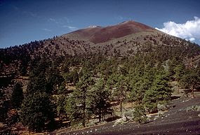 The most recent activity occurred just over 900 years ago at a place called Sunset Crater. Somewhere around 1080 to 1150 a.d. continuous eruptions formed the classic cinder cone. Native people living nearby were witness to the activity, and undoubtably their lives were changed as a result. The area and surrounding environment were shaped by eruptions and lava flows that still look as though they happened yesterday. Fortunately things have cooled off considerably, and the area has a number of hiking trails in and around the features. The area is now managed by the Park Service as Sunset Crater National Monument, and is located 12 miles northeast of Flagstaff on U.S. Highway 89.
Wupatki National Monument
After visiting Sunset Crater, visitors can continue on the scenic Sunset Crater - Wupatki
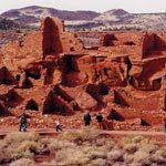 Loop Road to Wupatki, where 800 year old pueblo ruins are scattered across the high desert. Remnants of the vanished Anasazi culture, the abandoned structures tell of life in the shadow of the mountain. The ruins are scattered over a fairly wide area, and some can only be visited when Rangers lead scheduled hikes into otherwise off limit areas. Both Wupatki and Sunset Crater are located in close proximity, and visiting both monuments are a great option for a day's worth of activities.
The Navajo Nation, Cameron, and Highway 64 to the South Rim of Grand Canyon
After leaving Wupatki, turn right on U.S. 89 to continue the journey north. Soon after rejoining the highway, you'll enter the Navajo Reservation, which is the largest in the U.S. Covering 26,000 square miles in 3 states, the land sprawls across much of the southeastern edge of the Colorado Plateau. Characterized by stark badlands, buttes, and mesas the area is home to over 298,000 tribe members, most who live in widely scattered and remote settlements.
51 miles north of Flagstaff you'll encounter the intersection of U.S. Highway 64 coming in from the west.
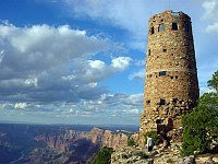 This scenic road leads to the eastern entrance of Grand Canyon located at Desert View (map). This road roughly follows the rim of the Little Colorado canyon as it travels northwestward towards the confluence with Grand Canyon. During the busy summer months it can be a less crowded place to experience the Canyon.
2 miles north of the highway intersection you'll enter the roadside community of Cameron. This is a good place to purchase authentic Native American crafts, as the store is owned by the Navajos, and the tribe will only sell the genuine article.
 The town itself is just south of the the Little Colorado gorge, and when passing over the bridge you'll often see the thin muddy trickle of water that exists most of the year.
Highway 160 to Monument Valley, the Four Corners and Navajo National Monument
14 miles to the north U.S. Highway 160 enters from the northeast. Travelers heading for Monument Valley, the Hopi mesas, Navajo National Monument, the Four Corners, or southwest Colorado should turn right here.
Tuba City and The Hopi Reservation
The oddly named Tuba City (a corruption of the Hopi name Tuuvi) and the companion community of Moenkopi mark the intersection of highway 160 with SR 264, a road that travels southeast to the Hopi Reservation. Visitors who
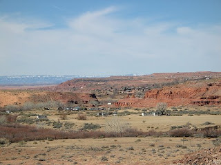 wish to visit the Hopi communities on First, Second, or Third Mesas can travel the 50 miles or so to see what is believed to be the oldest continuously inhabited community in North America at Oraibi, founded around 1100 a.d.
Navajo National Monument
The southwest is well known for the many prehistoric dwellings found throughout the region, but one of the best that few people know of is located on the Navajo reservation in northeastern Arizona. In remote Tsegi Canyon, ancestral puebloan peoples farmed the creek bottoms and lived in lofty cliff dwellings over 700 years ago. Keet Seel and Betatakin preserve the past history of these former residents. The ruins can only be accessed by guided Ranger tours, and are subject to seasonal
 availability. Navajo National Monument is reached by turning north onto S.R. 564, located 54 miles northeast of Tuba City.
U.S. 163 - Kayenta and Monument Valley
72 miles north of Tuba City is the town of Kayenta, where you'll find U.S. Highway 163 heading north for Monument Valley and Utah. The community is a good place to gas up, since towns are few and far between out here. Turning north onto U.S. 163, the highway climbs out of the valley where you'll spot a startling landmark thrusting skyward -
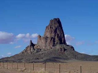 Agathla Peak. This jagged spire is the remnant of a volcanic plug after the softer sedimentary rock surrounding it eroded away. It sets the stage nicely for the better known sights ahead.
Monument Valley
Next to the Grand Canyon, probably the next most popular Four Corners destination is the iconic setting for so many Western movies - Monument Valley. The towering mesas, needles and
 buttes are massive sentinels over the lonely landscape. The area is located on the reservation, and is managed by the Navajo tribe, so be sure to stop in at the monument headquarters for available tours and information.
Four Corners
For those folks who want the distinction of being able to places parts of the body in four states at one time, you'll need to backtrack from Monument Valley to U.S. 160, and continue for 159 miles
 to the Four Corners Monument. Just be warned that more accurate mapping recently conducted shows the actual state boundaries may not be where the monument is. Read this article for more information.

No comments:
Post a Comment